

The French Creek Watershed was included in the vast Ohio Territory claimed by both France and England, and ongoing conflict among these empires in North America in the 17th and 18th centuries had a profound regional impact on native culture and European settlement. In 1749, in an attempt to reinforce its claims in the Ohio Valley and stem British involvement in the native fur trade, the governor of New France commissioned Captain Pierre Joseph de Celoron de Blainville to assert French claims to sovereignty in the Ohio Valley. The expedition planted lead plates with the French claims to sovereignty at intervals along its route. One of the plates was placed at the confluence of Riviere aux Boeufs and La Belle Riviere, French names for French Creek and the Allegheny River, at present day Franklin. A small native village of about ten cabins was located at the site at that time. 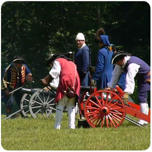
It was clear that whoever controlled the headwaters of the Ohio, including the Allegheny and French Creek drainages, would be positioned to control the entire route to the Mississippi River. In 1753 and 1754, the French erected a line of forts along the waterway: Fort Presque Isle in Erie, Fort de la Riviere au Boeuf in Waterford, Fort Machault in Franklin, and Fort Duquesne in Pittsburgh. This military build-up drew the attention of Virginia, whose Ohio Company had land interests in the Ohio Valley, as well as Pennsylvania traders and land speculators operating in the region. It was also a source for consternation among the Delaware, Shawnee and Mingo tribes who lived in the French Creek-Allegheny-Ohio watershed. In the midst of these tensions, George Washington appeared carrying an ultimatum to the French.