

Introduction
 Nestled along the banks of the French Creek Water Trail, these towns host many valuable community treasures that hold great history and importance to the region while also providing amenities to water trail users. A case study completed on four Pennsylvania water trails found that paddling groups spent a median value of $40 per day in local communities along the water trail during peak usage (ICF Macro, 2012)
Cambridge Springs
First settled in 1822 as Cambridgeboro, the town was renamed Cambridge Springs in 1897 after becoming known for its mineral springs. By the early 1900s, more than 40 inns and resorts were in operation as tourists flocked to benefit from the reported healing properties of the local spring water. Visitors to present day Cambridge Springs will find a number of small shops, restaurants, golf course and brewery. In addition to local eateries and historical attractions, paddlers may want to check with the borough office about camping in Firemen’s Park, directly adjacent to French Creek Valley Conservancy’s access area.
Creek Access:
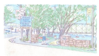
Cambridge Landing: French Creek Valley Conservancy partnered with the Cambridge Springs Borough to acquire a canoe/kayak launch on French Creek located in Firemen’s Park in downtown Cambridge Springs. Follow US routes 6E/19N just past French Creek bridge in Cambridge. Turn immediate left onto Poplar Street and follow to Hickory Alley. Turn left into Fireman’s Park pavilion parking area. The launch is straight ahead. *Firemen’s park has flush toilets, picnic tables, pavilions, and also has showers that can be opened by calling the Cambridge Springs Borough. Overnight camping in the park is permitted by reservation only.
Miller Station Road: The Pennsylvania Fish and Boat Commission also owns a launch just north of Cambridge Springs on Miller Station Road. Miller Station Road can be accessed by traveling north on Route 6/19 and turning right onto Miller Station Road. A current boat registration sticker or PFBC launch permit are required to use this launch.
Cochranton
The borough of Cochranton is nestled in the rich bottom land of the French Creek Valley. Situated at the confluence of French and Sugar Creeks, the area was first settled in the early years of the 19th century.
Cochranton takes great pride in its schools, churches and community services. Its businesses, clubs and organizations are just a short walk from the Creek and work together to maintain a quality small town lifestyle. Visitors to Cochranton will encounter a variety of small shops and restaurants, as well as convenient access to the usual supplies sought by kayakers and canoeists. The Cochranton Community Fair has been a tradition since 1928 and is held each year during the first week of August.
French Creek, Sugar Creek and other bodies of water in the Cochranton area (Big Sugar Creek, Deer Creek, Conneaut Marsh and others) provide excellent fishing opportunities, especially for smallmouth bass, walleye and northern pike.
Creek Access:
There is a Pennsylvania Fish & Boat Commission access located at the crossing of French Creek by Route 173. PFBC launch permits or boat registration stickers may be required per PFBC rules and regulations. There is a small parking area adjacent to the access and picnic tables are available.
Saegertown
Patrick and Arthur McGill were the first European settlers to lay claim the land now known as Saegertown, each staking out 400 acres. The area was eventually plotted as Saeger’s Town after a local property owner of the same name, and in 1955 the Borough Council agreed to the current name, “Saegertown.” The first bottling company in town was Eureka Springs, followed by the Saegertown Ginger Ale Company in 1920. When Saegertown Ginger Ale could no longer compete with national soft drink brands, they switched their commodity to bottled water. Saegertown Beverages, still sells Eureka Springs Water. Visitors to Saegertown have access to McGill House Museum, the Historical Society, and the Library. From a riverside park you can see a vehicular bridge decoratively illuminated with LED lighting. Basic services are available to paddlers, including sandwiches, pizza, gas, picnic areas, a laundromat, and ice cream.
Creek Access:
There is a Pennsylvania Fish & Boat Commission access located on Route 6/19 just ¼ mile south of the Borough of Saegertown. PFBC launch permit or boat registration sticker required.
Venango
Venango gets its name from a Native American term that refers to French Creek, although this wasn’t the town’s first name. The area was first settled by Europeans in 1797, and over the next 50 years, two sawmills and a grist mill were built.
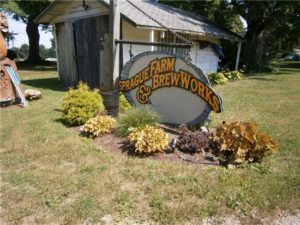
Today, Venango is a quiet village located directly on French Creek in one of the most biologically important sections of waterway in all of Pennsylvania. The village has a library, Fire Department, a local brewery–Sprague Farm & Brew Works and two golf courses; Venango Valley Inn & Golf Course and Country Meadows Golf Course. Venango Valley is located south of Venango on US Route 6/19. It offers an 18-hole course, a driving range, and two practice greens. The Country Meadows Golf Course located on Plank Road offers an 18-hole course featuring an island green, as well as a clubhouse, restaurant, and bar. The Venango General store also serves as restaurant and offers live entertainment.
Creek Access:
Unofficial access to French Creek is available at the site of the old Veterans Memorial Bridge.
Utica
Located in Venango County, Utica is a small borough situated along French Creek where a boat ramp and canoe access is available at Mile Marker 10 of the French Creek Water Trail. The community is very family friendly offering various camping and recreational opportunities including a fishing tournament held each year in June at French Creek Farm.
Utica Access:
About 7.5 miles west of Franklin and 9 miles from Meadville on Route 322, there will be a paved crossroads with a sign for Utica. Turn onto Utica Road. After driving down a steep hill, look for the parking area on the right side next to the railroad tracks before you cross the bridge over French Creek. The access is maintained by Western PA Conservancy. Canoe/kayak launch is down the foot path near the bridge with a paved river entrance. Limited parking is available.
Franklin
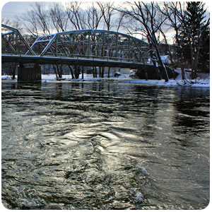
Serving as the county seat of Venango County, Franklin, has a population average of 7,000+. Every major architectural style used in western Pennsylvania from 1830 to 1930 can be found here giving Franklin the title: “The Victorian City.” The Historic District, from Federal Hill to Miller Park, is registered in the National Registry of Historic Places. Franklin’s location, at the confluence of French Creek and the Allegheny River was a key spot during the French and Indian War. Today, Franklin is home to Applefest, which is the largest craft festival in Western Pennsylvania. Hotels, taverns, theaters, and full dining options are a few of the many recreational amenities provided by the town.
Franklin Access:
PA Fish and Boat access is located in Franklin, south of the Route 322 bridge, along Elk Street between 3rd and 4th streets. Launch permits are required. Parking available.
Cranberry Township Trailhead Access: From Franklin cross the Allegheny River on US Rt. 322 E. Make first right hand turn into the bike trailhead about 500 feet past the bridge. Primitive ‘Leave No Trace’ camping and seasonal porta potties available. Approximately 0.5 mile walk into Franklin.
Cranberry Township Trailhead Access:
From Franklin cross the Allegheny River on US Rt. 322 E. Make first right hand turn into the bike trailhead about 500 feet past the bridge. Primitive ‘Leave No Trace’ camping and seasonal porta potties available. Approximately 0.5 mile walk into Franklin.
Meadville
Founded on May 12, 1788 by David Mead, the location was ideal for a settlement due to its position at the confluence of Cussewago Creek and French Creek. Today, Meadville is the largest city in Crawford County and serves as the County Seat. It is home to historic Allegheny College, the oldest college with the same continuous name west of the Allegheny Mountains. The Meadville Market House, built in 1870 is the oldest market structure in continuous use in the commonwealth of Pennsylvania. Amenities include four commercial hotels, a variety of restaurants and taverns, shopping, various recreational activities and festivals including the Thurston Classic hot air balloon event.
Creek Access:
Joe Cat Launch–In Meadville from Spring St, cross the Spring St Bridge over French Creek. Turn right onto Lincoln Ave. Follow to the stop sign and turn right onto Rogers Ferry Rd. Follow around the curve to Wadsworth Ave. Launch is on the left. Unload boats and carry in/out only. Park at Wadsworth Church or Lincoln Ave Ball Complex.
Cussewago Creek–PFBC. From the Mead Ave Bridge at Bicentennial Park in Meadville, take PA Rt 102 (Cussewago Rd) approximately 1.4 miles north, then turn right at the PA Fish and Boating Commission sign.
Bicentennial Park— From US Rts 6/19 in Meadville turn West onto Mead Ave then left onto French St (just before Mead Ave Bridge – look for historic log cabin), then right into the park. Access is straight ahead.
Wilson Chutes–PFBC. Follow US Rt. 322 E approximately 2.3 miles southeast of Meadville, turn right onto Wilson Chutes Road, then left into the parking lot just before Wilson Chutes Bridge.
Shaw’s Landing–PFBC. Follow US Rt. 322 E 6.1 miles southeast of Meadville, turn right onto “Town Hall Road” (sign may say Creveling), then across bridge over French Creek, turn left onto Wightman Rd (dirt) and follow 0.5 miles. Access is adjacent to Conneaut Outlet