

 Natural, Geology, Glacial
Geologic and climatic forces occurring between two million and ten thousand years ago radically transformed the French Creek Watershed. Originally rising near the mouth of today’s Clarion River, the stream flowed northward on a course that took it near present-day Franklin and Meadville, and on into Lake Erie. However, the successive advance and retreat of glaciers in northwestern Pennsylvania left massive moraines that blocked the northward flow of the stream, eventually turning it south.
Today, those vast glacial deposits from the Ice Age help to maintain the quality of water in the French Creek Watershed. Most of the glacial material contains calcium carbonate, or limestone, that acts as a natural buffer to acid rainfall, resulting in water pH levels ideal for the growth of a variety of species of plants and animals. Glacial deposits also serve as a vast aquifer in the region. Porous, saturated layers of sand, gravel and bedrock yield large volumes of water for human use.
Geography
French Creek and the West Branch of French Creek originate in Chautauqua County in western New York and flow southwest to their confluence in Erie County, Pennsylvania, to form the main branch. The South Branch of French Creek rises in southeast Erie County near the town of Corry, PA and flows west to its confluence with the main branch near Union City. The main branch then follows a southerly route through Crawford County, the northeast corner of Mercer County, and into Venango County where it joins the Allegheny River at Franklin, PA. The main branch is approximately 117 miles long.
 The French Creek Watershed, the area drained by French Creek and its tributaries, encompasses approximately 1,235 square miles of land, more than 790,000 acres. The stream has ten major tributaries and drains parts or all of 72 municipalities in four northwestern Pennsylvania counties, and also portions of Chautauqua County, New York. The population within the watershed is approximately 113,000.
The watershed comprises 11% of the drainage basin of the Allegheny River whose waters, in turn, flow into the Ohio and Mississippi Rivers and, ultimately, to the Gulf of Mexico. Thanks to its outstanding water quality, rich biodiversity, and notable history, French Creek is considered one of the most important streams of its size in the northeastern United States.
Geology and Topography
The bedrock of the French Creek Watershed was formed approximately 300-400 million years ago during the Paleozoic Era and comprises sedimentary sandstone, siltstone and shale deposited when the area was an inland sea. But it was glacial activity during the Pleistocene Epoch that gave the region its distinctive topographical and ecological character. Four separate glaciations occurred between two million and twenty thousand years ago. The Wisconsin Glacial Episode, the most recent of these, was itself characterized by four separate advances of ice.
In the watershed, the glaciers created broad uplands separated by linear valleys and long, rounded ridges. Vast deposits of glacial drift—clay, silt, sand and gravel—resulted in an array of soil types found throughout the region. Pleistocene glaciation also created many of the wetlands and glacial lakes in the French Creek Watershed, such as Conneaut and Pymatuning marshes, and Conneaut and Sugar Lakes. Conneaut Outlet, the remnant of an ancient streambed filled with glacial drift—is the largest marsh complex in Pennsylvania.
 Among the most dramatic results of glaciation was reversing of the flow of river drainage systems in northwestern Pennsylvania. Before glaciation, rivers in the region flowed north to the St. Lawrence. Glacial till blocked the flow of these rivers, including the French Creek drainage, eventually turning them south toward the Ohio River watershed. Originally rising near the mouth of today’s Clarion River, French Creek flowed northward on a course that took it near present-day Franklin and Meadville, and on into Lake Erie. Moraines from receding ice sheets altered its flow, eventually turning it on its present course.
The vast glacial deposits of the Pleistocene also help to maintain the quality of water in the French Creek Watershed today. Most of the glacial material contains calcium carbonate, or limestone, that acts as a natural buffer to acid rainfall, resulting in water pH levels ideal for the growth of a variety of species of plants and animals. Glacial deposits also serve as a vast aquifer in the region. Porous, saturated layers of sand, gravel and bedrock yield large volumes of water for human use.
Natural History
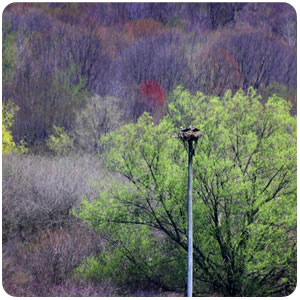
The flora and fauna of the French Creek Watershed is remarkably diverse, making it one of the most ecologically significant waterways in the state. While many streams and rivers in the Ohio River drainage have historically supported an array of plants and animals, human impact over the past century has resulted in the loss of many species. French Creek has been a fortunate exception.
The journals and correspondence of early travelers and settlers made frequent reference to great stands of hardwoods in the watershed. Today, second growth deciduous and evergreens are abundant, the virgin forests having largely disappeared during intensive logging in the 19th and early 20th centuries. The grasses and edge plants that flourished in the watershed’s meadows and prairies included pea vine (Lathyrus venosus) and wild bean (Strophostyles umbellate), two that were vital in sustaining browsing elk, buffalo and deer. With the abandonment of native fire-management practices, many of the early grasses and plants were displaced by European varieties.